
Don’t Know Your Parcel Boundaries? Need a map created? We Can Help!
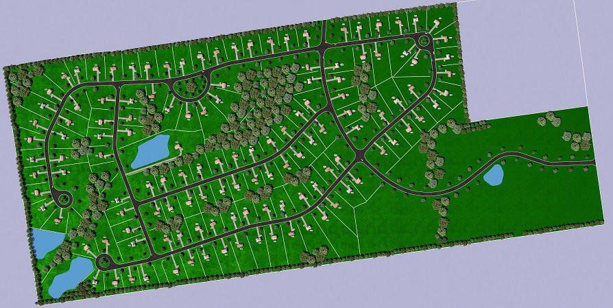
When you buy a house, you receive a mountain of paperwork, among which you might identify a plat mat. Essentially, this is a neighborhood map to which county assessors add parcel data. It gives you an idea of the place or town and how it fits within the city.
But as an owner or land developer, what sort of information can you find on a plat map? Is it something that you really need? Let's find out!
What Are Neighborhood Maps?
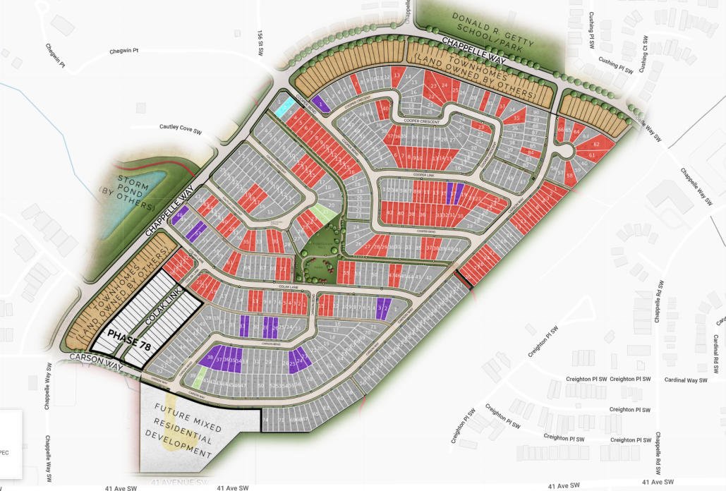
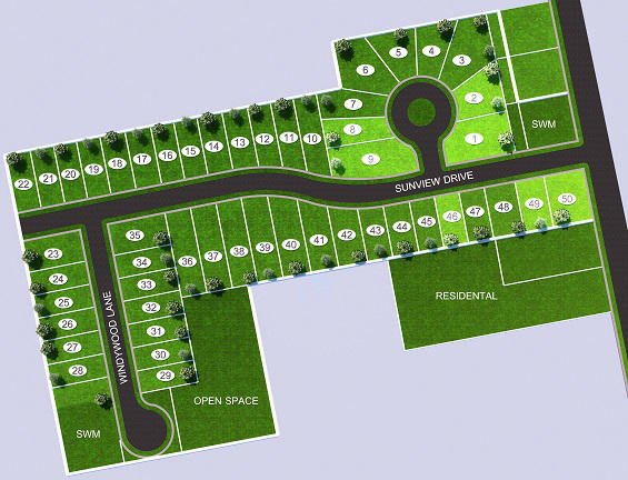
As the name suggests, these are charts that show details of a particular neighborhood. You will see specific features such as parcels of land and their position, acreage, shape of the plot, boundaries, and other relevant data.
What Is a Plat Map Used For?
A plat map will have all the information required to develop, merge, or subdivide a property. It is often used by land developers, oil and gas companies, and real estate agents to search for potential hidden issues. For instance, if you have any pipes or property lines you do not wish to trespass, this page will show accurate data on the land.
What Kind of Things Are Shown on Land Management Maps?
When county assessors and mapping professionals create plat maps, they will put down several types of information. A property owner will get access to the following data:

Directional Orientation
Every corner of the plan has a cardinal point drawn on it. The chart will show you the directional orientation of the home and where the doors and windows are facing.
A plat map is one of the best tools for you to choose a house with good lighting. For instance, if you want to get the most sun in the morning, you can go for a parcel number located in the east or south.
Parcel Number
In neighborhoods with multiple properties, every house or building will have a parcel number. This way, it will be much easier for you to search for the location of your property.
Owner Name
While not every map will show the owner name, some charts do. For example, if the property was commissioned by someone to live or invest in, the plan may include the owner name.
Property Lines Placement
Once the buildings have been constructed, identifying the property lines may become increasingly difficult. Trees, plants, and other details on the plot can make it difficult for specialists to survey in the future.
This is why land management plat charts show property lines with complete accuracy. If these boundaries are recorded, there will be no need to resurvey in the future.
Associated Easements
If you have any easements associated with the property, the plat map will show that information. This type of parcel data is essential when putting deed documents together. This will show that you are using the land legally.
Address and Street Names
A plat map may also include the address of a specific parcel, along with street names within a small area. By knowing the streets, it will be much easier for you to pinpoint the house on a map.
Is There a Difference Between a Neighborhood Map, Plat Map, Property Lines Map and Cadastral Map?
The names of these maps are quite similar, but there are a few differences. Neighborhood and plat maps are used on neighborhood scales, showing each separate parcel number within the city.
On the other hand, property line maps will show parcel boundaries for each property. Depending on ownership, the owner's name may also be found on the chart.
Cadastral maps are similar to property line layouts, but they are slightly more detailed. If you want to make any improvements to your property, this plan will help you locate the best location for them. It will also prevent you from going beyond your property line.
What Techniques Are Used to Create a Cadastral Map?
To create a cadastral layout, engineers use techniques such as the plan table method, chain surveying, and tachometry. GPS surveying methods are also frequently used to survey the land accurately. To gauge the size of the property, an electronic distance meter (EDM) will also be used for the cadastral survey.
What Challenges Are Involved in Creating Property Lines Maps?
Creating property or county maps can be challenging even for professional land developers. These are the most common problems they may come across:
Insufficient Property Information
To create a survey layout for the property, you must have access to accurate information. You need to know the acreage, type of land, land levels, installations, and more. Unless the property owners have up-to-date information, creating a chart of the area can become a challenge.
Delimiting Parcel Boundaries
Each county will have its residential areas and neighborhoods delimited accurately. If the exact acreage is not available, creating a precise document may be very challenging.
Outdated Parcel Data
Very often, land developers must make updates on land that has not been surveyed for a long time. If the existing data is outdated, they may need to do thorough research to obtain the relevant information. This can be quite time-consuming.
Frequently Asked Questions
If you have any other questions, you can find the answers here:
Can I Draw a Neighborhood Map Myself?
As long as you have the tools and knowledge necessary, you can draw a neighborhood or parcel layout yourself. For example, some land developers draw their own maps. However, you will need certain equipment to make sure everything is accurate and up to date, and you can save lots of time and money by outsourcing your plan creation to a company like us at Render3DQuick.
Is It a Bad Idea to Try and Draw Your Own Plat Maps for Your Land Parcels?
More often than not, it is a bad idea to draw your own parcel maps. Unless you are a professional, you may not include all necessary aspects of the land, which will lead to inaccuracies. A professional may then have to survey the land once again when making improvements to your property in the future.
Are There Services That Will Draw Property Lines Maps for You?
Yes, there are 3d rendering firms like us here at Render3DQuick.com who specialize in mapping that can help you create an accurate plan. We know how to gather the required data and search for information, creating a piece that developers can use. Whether you need a map for an individual residence or the entire neighborhood, as a chart drawing service we can help you out.
How Much Does It Cost to Have a Cadastral Map Created?
The average cost for us to create a cadastral map is somewhere between $380 and $540. The final rate will depend on a variety of factors such as the service used, the data available, and the size of your parcel of land.
The Bottom Line
Creating a layout for a neighborhood or county is no easy job. Whether you plan on developing a neighborhood or you wish to make updates to your home, a neighborhood or plat map can prove very useful.
If you need help creating a cadastral, neighborhood, property lines or plat map give us a call on 1-877-350-3490 or request a quote here - we'd love to make the process easy for you!


Alex Smith
Manager & Co-Owner Render 3D Quick
Alex Smith is a manager and co-owner at Render3DQuick, with over 6 years’ experience project managing their large team of 3D rendering professionals. Alex is obsessed with architecture and is a CAD design specialist in his own right and an expert in the field of architectural visualization, 3D rendering, and virtual reality tours.
As the first point of contact when you get in touch with Render3DQuick, Alex loves sharing his knowledge and answering any questions you may have about architectural visualization or the latest technologies and techniques they utilize.
Connect with Alex on LinkedIn here.